Machu Picchu Circuit Map Guide: Reading the Routes
How to read the official Machu Picchu route map — the three circuits and their numbered routes — and match your timed ticket to the views and monuments you actually came for.

Photo: Letian Zhang / Unsplash
- ✓The official map divides the citadel into three circuits, each split into numbered routes — your ticket buys one route, not the run of the place.
- ✓The circuits are largely one-way: the map shows a direction of travel, so what you see is decided by the route you booked, before you arrive.
- ✓Circuit 1 (upper) holds the panoramic overlook, the long approach routes and the Machu Picchu Mountain climb; Circuit 2 (classic) pairs that view with the urban sector; Circuit 3 (lower) reaches the riverside temples and carries the Huayna Picchu add-on.
- ✓Read the map for what each route reaches — the postcard frame, the Temple of the Sun, the Intihuatana, the Inca Bridge, the Sun Gate — then pick by what matters most to you.
Why there is a map at all
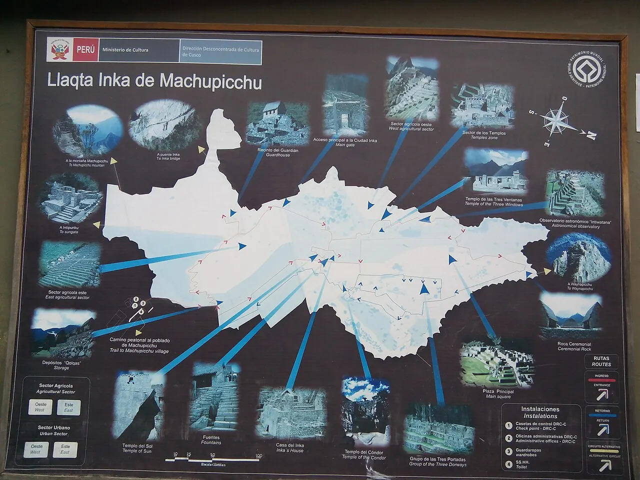
Machu Picchu used to be a place you wandered. You climbed up to the Guardhouse for the postcard, drifted down through the temples, doubled back to the terraces, and pieced the city together at your own pace. That Machu Picchu is gone. Since Peru's Ministry of Culture reorganised the visit, the citadel is walked along defined circuits, each made up of numbered routes, and the official map is the document that governs your day. Learning to read it is the difference between arriving with a plan and arriving with a surprise.
The reason for the map is preservation as much as crowd control. Funnelling visitors along set, largely one-way paths spreads footfall, protects the fragile stonework, and keeps thousands of people moving through a small, steep site without gridlock. For you, the practical consequence is blunt: the map decides what you see. You do not buy a ticket to Machu Picchu in the abstract; you buy a ticket to one route through it, and the route is chosen at the moment of booking.

How the map is organised: circuits and routes
Start with the big shapes. The map splits the citadel into three circuits, numbered 1 to 3, that broadly track altitude across the site. Circuit 1 stays high on the upper terraces and the panoramic side. Circuit 2 is the classic full traverse, dropping from the overlook into the heart of the city. Circuit 3 runs lower, closer to the river and the royal and ritual core, and is the circuit the Huayna Picchu climb attaches to (Machu Picchu Mountain attaches to Circuit 1).
Within each circuit, the map draws several numbered routes — ten across the system in total — that are essentially the longer and shorter, higher and lower variants of that circuit's path. One route might give you the full panoramic approach with the Sun Gate; another, a more compact loop. The numbers on the map are these routes. When you book, you are choosing a circuit and, within it, a specific route, and that pairing is what is printed on your ticket and checked at the gate.
The single most important thing to read off the map is the arrows. The circuits are largely one-directional. The path flows one way, and backtracking to revisit something you passed is generally not part of the design. This is why the order of monuments is fixed before you walk: the map has already decided the sequence, and you are following it.
- Three circuits (1–3) — roughly upper, classic and lower bands across the site.
- Ten numbered routes in total — the variants within each circuit, shorter or longer, higher or lower.
- Largely one-way arrows — the map sets the direction and sequence; little or no backtracking.
- Your ticket = one circuit + one route, fixed at booking and checked at the entrance.
Reading the map for the views you want
Once the structure makes sense, read the map for landmarks. Almost everyone arrives wanting a handful of specific things, and each lives on particular parts of the map. Knowing where they fall lets you choose a circuit that delivers your non-negotiables rather than one that quietly skips them.
The classic postcard frame — the citadel laid out below with Huayna Picchu rising behind it — sits high on the site, on the upper path near the Guardhouse and the agricultural terraces. The upper-band routes are the ones that deliver this elevated overlook cleanly. If the panoramic shot is the image you have carried in your head for years, the map is telling you to look toward Circuit 1 or the higher reaches of Circuit 2.
The urban sector — the temples, plazas and the granite Intihuatana ('hitching post of the sun') at the city's heart — sits in the middle and lower bands. To walk among the buildings rather than only look down on them, you want a circuit whose route descends into the city. The classic traverse of Circuit 2 is built precisely to pair the overlook with this descent, which is why it is the all-rounder so many first-timers choose.
The Temple of the Sun and the lower royal and ritual structures sit on the lower band, the territory of Circuit 3 — which is also the circuit the Huayna Picchu climb attaches to. (Machu Picchu Mountain, the other big summit, branches off the upper Circuit 1 instead.) So if your dream is to stand beneath the Temple of the Sun or to climb Huayna Picchu, the map points you down, not up.
The long approaches: Sun Gate and Inca Bridge
Two famous walks sit at the edges of the map, and people often miss that they are not automatically included. Inti Punku, the Sun Gate, is the high pass where Inca Trail trekkers get their first sight of the city; it is a there-and-back walk along the upper approach. The Inca Bridge, a vertiginous timber-and-stone span on a cliff path, is another short out-and-back from the upper terraces. Both attach to particular upper-band routes rather than appearing on every ticket.
If either of these is on your wish list, find it on the map before you book and choose the route that reaches it. Adding them on a whim once you are inside is usually not possible, because the one-way design and the route on your ticket have already set your path. The map rewards the visitor who reads it in advance.
The peaks on the map: Huayna Picchu and Machu Picchu Mountain
The two big climbs read as branches off the main paths on the map. Huayna Picchu is the steep, iconic sugarloaf that rises directly behind the citadel in every postcard; Machu Picchu Mountain is the higher, longer ridge on the opposite side, giving a sweeping aerial perspective for the effort. Both are sold as separate add-on permits, tied to specific circuits and entry windows, and both sell out among the earliest things of all.
On the map, the takeaway is that a peak is not a detour you bolt on at will — it is part of the route you buy. Because the climbs attach to particular circuits, choosing a peak partly chooses your circuit for you, and therefore which of the down-low monuments you will pass on the way. Decide on the peak first, then let it steer your reading of the rest of the map.
Putting the map to work: a reading method
Here is a simple way to use the official map before you commit. Work from your priorities outward rather than from the circuit numbers inward, and the right ticket reveals itself.
First, name your one non-negotiable — the panoramic overlook, the urban sector, a specific peak, or one of the long approach walks. Find it on the map. Second, see which circuit and route band it sits in. Third, check what else that route picks up along its one-way path, so you know what you gain and what you trade away. Fourth, confirm the practical fit: a peak or a long approach adds real time and climbing, so be honest about pace and altitude. Only then do you book the circuit and route that carries your non-negotiable.
This is also the moment to remember that the map is a living document. Circuit definitions, the exact monuments on a given route, capacities and the rules around the peaks are set by the Ministry of Culture and have been adjusted since the system was introduced in 2024. Read this guide for the method and the official map for the current specifics, and verify anything load-bearing — a particular monument, a peak's availability — at the time you book.
- Name your single non-negotiable and locate it on the official map.
- Identify the circuit and route band it belongs to.
- Trace the one-way path to see what else that route reaches — and what it skips.
- Sanity-check time, climbing and altitude before committing.
- Verify current circuit and monument details on the official source before booking.
Orienting yourself on the ground
The map makes far more sense once you can place the citadel in its setting. Machu Picchu sits on a saddle high above a hairpin in the Río Urubamba, with Huayna Picchu to the north and the broad bulk of Machu Picchu Mountain to the south. The upper circuits look down the long axis of the city; the lower ones thread among its buildings near the river side. Holding that geography in your head turns the printed routes from abstract numbers into a walk you can already picture.
Map pins
Map data © OpenStreetMap contributors · Tiles © OpenFreeMap
Related guides

Machu Picchu Circuits Explained
Compare the three official circuits and ten routes — panoramic, classic and royal — so you book the right experience: the postcard view, the temples, or the add-on peaks.
Read guide
Machu Picchu Highlights: What You'll See
The set pieces inside the citadel — the Guardhouse overlook, the Temple of the Sun, the Intihuatana, the Sacred Rock, the Sun Gate and the Inca Bridge — and which circuit and route reaches each one.
Read guide
The Best Machu Picchu Circuit for Your Visit
There is no single best circuit — only the right one for you. How to choose by the classic view, photography, ruins depth, hiking ambition, mobility, family pace and ticket scarcity.
Read guideMore in Tickets guide
6Best Circuit for the Classic Machu Picchu Photo
Which routes deliver the iconic postcard view, when the light is best, how mist and season play, and how to avoid the photo disappointment that catches first-timers.
Read guide
Do You Need a Guide at Machu Picchu?
When a licensed guide is required or simply worth it, private versus shared, how the route flow works, and how to book ethically.
Read guideHow to Book Machu Picchu Tickets
The booking sequence, in order: pick the date, choose the circuit and route, secure the entry window, enter passport details, then arrange the train and your overnight.
Read guide
Intipunku, the Sun Gate: How to Reach It
The Sun Gate above the citadel — the Inca Trail's grand entrance and a stiff out-and-back for ticket holders. How to reach it, the seasonality, the views and the effort involved.
Read guide
Last-Minute Tickets in Aguas Calientes
Buying Machu Picchu entry in person at the foot of the mountain — the official sales offices in Machu Picchu Pueblo and Cusco, the real risks and caveats, and why this is a backup, not Plan A.
Read guideMachu Picchu Entry Rules
Bag size, food, tripods, walking sticks, re-entry, one-way routes and the behaviour that keeps you inside the gate — the practical rules to verify before you go.
Read guide