
 Photo: Wikimedia contributors · See source
South Valley & Huacarpay
Travel through Tipón, Pikillaqta, Huacarpay, Andahuaylillas and Huaro on an unhurried South Valley loop.
- Allow
- 1–2 days
- Route
- 98 km
- Drive time
- 1 hr 39 min
- Stops
- 6
South of Cusco, Tipón’s precise water channels and Pikillaqta’s Wari urbanism widen the story beyond the headline Inca sites. Beside the archaeological zone, Huacarpay’s reed-fringed wetland creates a natural pause before Andahuaylillas and Huaro add richly painted colonial interiors.
This is an altitude-aware driver route, not a race between monuments. Use the established highway and signed site approaches, carry water, verify church and archaeological access, and leave space for birdlife and weather rather than extending onto unsigned rural tracks.
The road, in one glance
Pinch or scroll with Ctrl / ⌘ to zoom
Drawing the route…
The route earns
its distance
Each pin is selected as a place to do something—not merely proof that you passed through.
 Photo: Wikimedia contributors · See source
Cusco
Begin only after acclimatizing, with a driver and the day’s cultural-site access checked.
Cusco or Cuzco is a city in southeastern Peru, near the Sacred Valley of the Andes mountain range, and the Huatanay and Urubamba rivers. It is the capital and largest city of the eponymous Cusco Province and Cusco Department. It has historically been one of the largest cultural, economic and political centers of Peru.
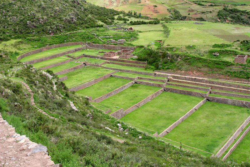 Photo: Wikimedia contributors · See source
Tipón
Terraces and still-flowing channels form an elegant Inca hydraulic landscape.
Tipón is a sprawling early fifteenth-century Inca archaeological site that is situated between 3,250 metres (10,660 ft) and 3,960 metres (12,990 ft) above sea level, located 22 kilometres (14 mi) southeast of Cusco near the village of Tipón. It consists of several ruins enclosed by a powerful defensive wall about 6 kilometres (3.7 mi) long.
Photo: Wikimedia contributors · See sourcePikillaqta
Long walls and a planned Wari settlement predate the Inca expansion around Cusco.
Pikillaqta (Quechua piki flea, llaqta a place (village, town, community, country, nation), "flea place", also spelled Piki Llacta, Pikillacta, Piquillacta, Piquillaqta) is a large Wari culture archaeological site in the Quispicanchi province of the Cusco Region of Peru. Pikillaqta is a village of the Wari people. Wari was the centre village and other cities like Pikillaqta were influenced by it.
 Photo: Wikimedia contributors · See source
Andahuaylillas
A modest village church contains one of the region’s richest painted interiors.
The Andahuaylillas District is one of the twelve districts in the Quispicanchi Province in Peru. Created on January 2, 1857, its capital is the town of Andahuaylillas. It is located 45 km South of Cusco.
 Photo: Wikimedia contributors · See source
Huaro
Another painted church and small highland town reward a less hurried route.
The Huaro District is one of the twelve districts in the Quispicanchi Province in Peru. Created by Law No. 11863 on September 26, 1952, its capital is the town of Huaro.
 Photo: Wikimedia Commons contributor · See source
Huacarpay Wetland
Reed beds, shallow water and cultivated hills form a protected high-Andean wetland beside Pikillaqta.
Lucre–Huacarpay is a high Andean wetland complex southeast of Cusco and a designated Ramsar site. Its connected lagoons, reed beds, marshes and archaeological landscape provide feeding and refuge habitat for resident and migratory birds.
Drive the conditions,
not the itinerary.
Use a driver familiar with the South Valley, carry altitude and weather layers, and keep every leg to daylight. Use established viewpoints around Huacarpay; do not enter wetland or farm tracks.
Checked against
the people who run it
Distances and driving times are planning estimates. Conditions, closures, ferries, permits and park rules can change, so check the linked official guidance before setting out.